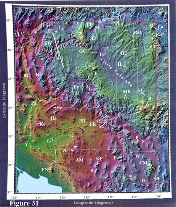
Elevations are color-coded.
- Lime green is within 1000 ft of sea level
- pink is 1 to 3 thousand feet
- blues about 4-6000 ft
- blue-greens above about 7000 ft
Figure 31. Topographic Map of Arizona.
The three provinces are distinguishable - Basin & Range in the south, a central mountainous belt, and the Colorado Plateau region in the north, cut through by the Grand Canyon. Some places are keyed into the diagram with an index. Compare this illustration with Figure 27, the map of regional drainage basins.
Obvious is the Hurricane fault (labeled) that cuts through the Grand Canyon and extends south from there. This is the most active current fault zone in Arizona. This fault merges with the Grand Wash cliffs that form the downstream boundary of the Colorado Plateau where the Colorado River exits into Lake Mead. And this fault basically forms the imposing mountain front just east of Salt Lake City called the Wasatch Front, where it is rightly the exact boundary in Utah between the Colorado Plateau and busted-up Basin & Range country to the west. I-15 traverses along it between Las Vegas and Salt Lake City.
The Mogollon Rim is obvious in the central part of the state. It is best seen along highway 87 linking Payson and Winslow. A great view of the Rim, the tall south-facing cliff, is seen very near the entrance road to Tonto Natural Bridge State Park, that has on display a curious natural bridge of special limestone called travertine formed by a spring along the canyon bottom which the stream then undercut, forming a bridge. North of the town of Pine the highway climbs (going north) through most of the entire Paleozoic section, then flattens out on top of the Kaibab Limestone. This is the southern lip of the saucer that is the Colorado Plateau.
I have seen it recently announced that the famous Four corners monument, north of the Carrizo Mts, is not in the right place - it is out by better than a mile. Oh well. If you go there, be sure to make a side trip to the goosenecks of the San Juan River, a great case of entrenched meanders of the river that begins in the Durango area of SW Colorado. No one has yet to explain why rivers meander. It is a complex way for flowing water to use up gravitational energy in moving its sediment load downstream. If there's no gradient down to the ocean then the stream valley fills with sediment.