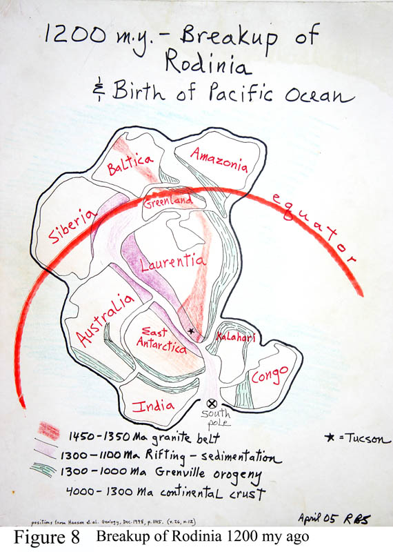
Figures 8 and 9 are maps of the supercontinent Rodinia, existing from about 1,400 to 1,100 m.y. or 800 m.y. ago (exact time frame contains uncertainties). The land labeled Laurentia is basically North America with Greenland and hunks of northern Europe and Asia attached, along with the core of South America. Amazonia may have sat farther south than drawn, off the east coast of North America. The black star in Figure 8 is Tucson. Soon after the single land mass broke up, the southern collection of continents broke away to form Gondwanaland - Australia, Antarctica, India, Africa that sat for a time at the south pole and became glaciated. That's why there are glacial surfaces in southern India - early evidence for continental drift - tropical regions don't get big ice caps. Note that southern Arizona was well south of the equator.
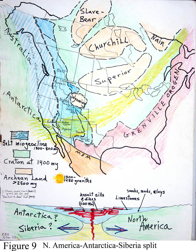
The patterned green-colored strips of Figure 8 are zones of mountain-building due to various continental collisions of various ages. But then the purple belt in Figure 8 along our west coast formed as Rodinia developed a rift (pull-apart) zone which sank under shallow sea water, just as in a taffy-pull, with Antarctica and Australia still attached to our west coast region, and so rivers from the lands brought in sediments - sands, muds, limestones - that deposited all along the purple belt. Our west coast ran literally through about Yuma, as California was yet to be conceived - in other words, today the lands of Rodinia that sat west of Yuma are now under the Antarctic ice sheet. After some time, as Rodinia finally broke up totally, this rift zone then turned into the crack which widened into the birthing of the modern Pacific Ocean. See Figure 9 (above), where the solid blue area is the sediments still found sitting on north America, while the adjacent striped blue area are the rift-filling sediments sitting in Antarctica and Australia.
The sediment package deposited in this rift setting (precursor to the Pacific Ocean basin) is seen in Arizona in two spectacular places. Highway 60/77 through the Salt River Canyon (halfway between Globe and Show Low) passes through the entire sediment package in the canyon, where the group of sediments is called the Apache Group (Figure 58, 63 and 64). Here the section is cut through by several thick horizontal sills of diabase - basalt magma forced between the sediment layers while underground. Figure 9 cross-section (bottom of figure) shows the red banded layers of diabase intrusions at 1,100 m.y. ago - this diabase is seafloor basalt cooled slowly underground, and marks the cracking of the continent and forceful intrusion of basalts. For the more adventurous, the secondary road from the Tonto basin to the town of Young, called highway 288, cuts its way over the top of the Sierra Ancha. The road has spectacular views of Lake Roosevelt. Most of the entire mountain range is the sediment layers of the same Apache Group with thick diabase sills. But a still more spectacular view of these sediments is from Desert View, eastern end of the main loop road in Grand Canyon National Park. These sediments are Apache Group equivalents, here called the Grand Canyon series, and are the tilted various red-colored bands seen just above river level far below, beneath the flat Paleozoic cover layers. These lower layers can be seen in Figures 11 and 12. In northern Utah, most of the entire Uinta Mountains are made of these sediments, mostly thick cliff-forming layers of sandstone. You MUST travel Highway 191 north out of Vernal over the top of the Uinta Mountains in this lesser-seen part of Utah, where you can see the effects of recent glaciation. The Uinta Mountains has a singular distinction - it is the ONLY major mountain range in the West that trends east-west. For anyone traveling in British Columbia along the trans-Canada highway, much of the spectacular mountainous scenery, such as around Lake Louise, is composed of many thousands of feet of layered sands and muds in this same sediment package, called the Belt series.
Figures 8 and 9, and the geologic map, Figure 30, show another odd feature, labeled '1,300-1,450 m.y. granite belt.' This long zone extended across three or four once-joined continents as a discreet arc-like zone of granites emplaced as many individual batholiths. The morphology of the rock is unusual and easily identified. It is a mystery why this should have happened along a single band that crosses the continent. In southern Arizona these granites are seen in many places, even on the Tohono O'odham Reservation and around Oracle-Winkelman. Around Tucson it is called the Oracle granite. This subtle existence of the great arc is identified by large-scale regional studies and is quite mysterious. There is some evidence that much of many of the continents were 'buoyed upwards' at this time so that major erosion of the surfaces ensued. The mechanism responsible may have been major quantities of granites produced deep and rising to 'underplate' the continental crust and thicken it. A thicker crust floats higher because of isostatic adjustment. But why did it happen? It was a deep underground event that was occurring during the time of the great unconformity (quiet time on the surface) - a major internal readjustment.
How are maps of ancient geography like this drawn? The key point is that many kinds of rocks have a 'memory' of the Earth's north magnetic pole position when they formed - their magnetic minerals lined up with the poles. We combine this direction in space with the age-dates of rocks of the same age on all the continents, and so can calculate continental positions. This map has required many, many happy hours of research of thousands of geologists and lots of computer time.
Another major though subtle issue surfaces with this figure. Many major features of Earth's past conditions are expressed in subtle ways. The exact kind of limestone deposited worldwide at this time was actually a different rock called dolomite, which has half of the calcium replaced by magnesium (limestone - CaCO3; dolomite - Ca,MgCO3). Until about 1,000 m.y. ago dolomite formation was far more common than limestone, while afterwards limestone is common and dolomites became increasingly rare. The reason for this change is not understood except that dolomite seems to form in very warm salty waters. The carbonate rocks in the Apache Group and other age-equivalents are actually dolomite. There is a thick white dolomite bed in the Salt River Canyon at the last hairpin turn before crossing the river headed north out of Globe, and a convenient parking area on the outside of the bend. Fossils of an ancient life form can be found in these dolomites, called stromatolites, appearing as mushroom-shaped masses. They were made by colonies of photosynthetic bacteria with modern relatives living in intertidal seawaters at low latitudes, with a showplace in Shark Bay, western Australia. The fossil record indicates that these critters INVENTED the process of photosynthesis, without which there would not be animal life, nor Mac computers, freeways, city slums. How's that for subtlety?
Figure 7 also shows two other features: The 'Grenville Orogen' was a major collision belt along our east and SE coast formed during 1,100 +/- m.y. continental collisions, during Rodinia time. Big mountains once existed there, westward into Texas. The other feature: In the northern lands, Figure 9 shows four land masses of Archean rocks - Slave, Churchill, Nain and Superior provinces. These are remnants of the earliest granite islands that make up the very core of North America. They were welded together by the very first episodes of continental collisions, which occurred some 3,000 m.y. ago. Think of four blocks of wood in your bathtub, and then solidify the water with jello to freeze the blocks into place. The jello rock is called schist, obviously layered and loaded with mica crystals. That is the oldest portion of the continent called the Canadian shield, a giant mix of granites and schists. The same mix of granites and schist form the basement terrain of our region at a later time.
Also figure 9 shows the extent of the lands of North America at the time, the approximate meaning of the word 'craton' - the stable and long-lasting continental interior.
Another major climactic event should be mentioned - considered as the grandest glacial epoch of all time, now labeled by some as the time of 'Snowball Earth.' Proposed by the Canadian Paul Hoffman, whom I've heard speak on the subject, he posits that there were two (possibly three) long intense glacial times at about 700-600 m.y. ago, each lasting some 20 m.y. or so, each followed by a time of intense hot climate, also 10-20 m.y. long. (This event is 40 times longer than the current ice ages of the Pleistocene.) During Snowball ice times the oceans froze partially over since we can find big stones in seafloor muds far offshore that were dropped there by big melting ice sheets that carried them far away from the continents. These are called 'dropstones.' Then, during the hot intervals, on all continents there were deposited great beds of dolomite in shallow waters, formed as noted above during hot times. The name 'snowball' derives from the likelihood that during the ice times the entire planet may have looked like a snowball with most or all of the oceans frozen over and ice covering the continents. Some suggest the top half-mile of the oceans was frozen solid. These extreme climactic conditions must have been a distinct bottleneck for life's abundance. We search for a cause. Some suspect the sun's behavior, or orbital disruption by a passing star, but so long ago, the culprit has drifted far away.
Amazingly, there is good Snowball Earth evidence found in Death Valley National Park. Very near the lesser-seen Wildrose entrance station in the far west part of the park are seen dropstone boulders in tilted-up ocean-bottom muds in a sequence called Kingston Peak diamictite; and in the picturesque canyon walk up Mosaic Canyon above Stovepipe Wells campground, all the hard lime layers in the canyon narrows are beautiful dolomite beds from this time, formed under the searing hot sun times between the glacial periods. The same dolomites are seen in a totally commanding scenic drive down Titus Canyon, still in Death Valley park, for the more adventuresome. Because of periodic canyon flooding check with rangers over road conditions.

