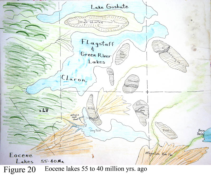
Figure 20. Northern Arizona during the time of the Eocene hyper-wet climate. Following the tumultuous Laramide orogeny, there was a reprise of volcanic action in the region before the next cycle. But for a time at about 50 m.y. ago (+/-) the entire world's climate went berserk and turned tropical. For unknown reasons (as far as I have heard) the climate got hot and humid - everywhere. This was about the time when the first grasses appeared. Alligators and palm trees grew on Ellesmere Island in the Canadian arctic, where the sun doesn't even shine for months each year. Those fossil species indicate that it couldn't even freeze in the wintertime.
On Arizona's land the effect was pretty profound. On the Colorado Plateau there were a series of really large lakes because of all the rain that covered much land. A cartoon guess at a lake in northern Arizona that some call Long Point Lake in Arizona is seen in the figure. Still larger lakes existed across lots of Utah and Wyoming. They may or may not have been as well-connected as shown in the figure. They go by various names, as shown - Lake Flagstaff, Green River Lake, Lake Claron, Lake Goshute. The small fish fossils on yellow shale that everybody buys for their grandchildren is from some quarries in the Eocene lakebeds of Lake Goshute in Wyoming.
Curiously, Long Point Lakebeds infilled a side canyon to the western Grand Canyon called Peach Springs Canyon. This is the takeout point for many Grand Canyon raft trips. But for the lakebeds to be inset into Peach Springs Canyon means the canyon was already there, and cut down to modern river level BEFORE Eocene time. This is evidence for some great antiquity for the entire western Grand Canyon. The age of eastern Grand Canyon is another problem. Some of us geologists who have studied the 'Grand Canyon problem' now say that much of the Grand Canyon was cut by a EAST-FLOWING river coming out of the Mogollon Highlands (Figure 17) and onto a low-elevation Colorado Plateau region, during Laramide time, beginning 70 m.y. ago. Another camp says that the entire canyon was cut by the Colorado River within the past 6 m.y.. They are (more) wrong, we are (more) right. The real history is a bit convoluted.
The world's wet & warm climate had profound effect on the weathering and disintegration of rocks at the surface. Thick soils were produced, and strange effects also. Granites at the surface quickly weathered in the worldwide hot tropical conditions, to soon be composed of a particular leached clay called kaolin mixed with insoluble quartz crystals. These clay masses are now the world sources for the kaolin clay starting material of porcelain ceramics, and when the high rainfall leaching process runs to completion a strange rock called bauxite is formed which is made 80% or more of aluminum oxide, Al2O3, which is the worldwide primary ore for the production of aluminum metal. Our aluminum ores worldwide are a product of the Eocene hot wet climate.
In most regions, the period of time 55-30 m.y. ago is mostly devoid of rocks of any kind, as tremendous rains and lots of erosion proceeded to strip rocks away and transport the debris to the oceans. Fantastic quantities of weathered and eroded rock were moved from the continents to the nearest seas in Eocene time.
But some fossil evidence exists for a rugged time for early mammals. After dinosaur extinction, the mammals became center-stage with new ecological niches and soon multiplied into monsters like titanotheres that lived through the Eocene swelter. But then with the drying and cooling of the Oligocene period, the early mammals were replaced by ancestral forms of modern savannah beasts, primal lions, bears, hippos, and even primates. Grasslands and grazers evolved.
