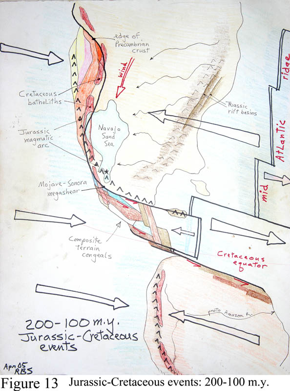
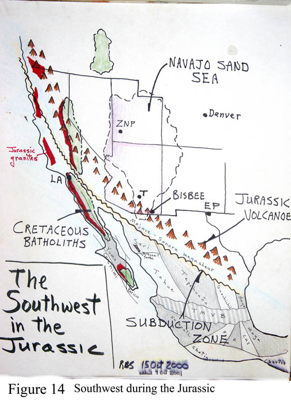
Figures 13 and 14. North America during the Jurassic.
(Mesozoic time contains 3 parts - Triassic, Jurassic, Cretaceous periods.) At the beginning of the Mesozoic Era the supercontinent of Pangea broke up into pieces due to mega-forces beneath. The result upon the western portion of North America was that it rose up significantly above sea level, and Triassic deposits on the Colorado Plateau tend to be bright red-brown-colored river floodplain deposits (Moenkopi formation), covered over by lakebed muds colored gray, blue, purple (Chinle formation) that contain abundant fossils of pre-dinosaurian reptiles, including the fantastic Petrified Forest National Park fossil forest beds. The origin of the bright red coloration of the beds in the region is a mystery. It is lots of red iron oxide in the sediments, but why? The petrified forest grew around a large inland lake; dead trees collected and sank in the lake, became buried in the bottom muds had their organic matter replaced by colorful silica. Triassic deposits would have sat atop the Grand Canyon - they may or may not have even been deposited there they're found on all sides of the Grand Canyon region.
During middle Triassic time (225 m.y.) we find fossils of the first dinosaurs, and, very near them, the first fossils of mammals, little guys similar to shrews. We co-evolved with them, but the dinos quickly took charge, turned into monsters--that is, until their sudden demise some 160 m.y. later.
Events during the Jurassic period, the middle portion of the great Mesozoic Era, did much to bring the shape of North America into modern times. Note the big arrows in the figure that tell us that the Atlantic Ocean was widening as the mid-Atlantic spreading center was pushing the basin open, as North America was colliding with the Pacific Ocean so that a subduction zone became active along the west coast. But the west coast was far different than now. Two big events were ongoing in Jurassic time. First, note the line of big volcanoes labeled 'Jurassic magmatic arc' on Figure 13 which lay just inside of the subduction zone, which crossed the continent just south of Tucson. (The line of volcanoes on Fig 13 are the black inverted 'V's; the subduction zone, not shown, lay just to the west. On Figure 14 they look like a mountain chain.) The modern Cascade volcanoes of the Northwest are behaving similarly. Volcanic rocks and granites of Jurassic age are found all across southern Arizona, and are prominent in the Santa Rita and Baboquivari Mountains. The granite at Kitt Peak is of this age. Mt. Wrightson ridge in the Santa Ritas is a highly eroded remnant of a Jurassic-age rhyolite volcano. The big ore deposit at Bisbee, now dormant, is a big Jurassic-age granite mass, rich in copper-silver-gold which probably was once covered over by its own volcano, long since eroded away.
In a few places scattered throughout the West you can find deposits of an unusual rock called jade. Prized by stonecarvers for its toughness over the millennia, it is of unique origin. Jade forms within subduction zones when extremely hot mineral waters act on seafloor basalt rocks under hyper-fantastic pressures to form blanket layers. Then, under pretty unusual circumstances some of the 'subduction complex' can get brought by faulting up to the surface far above as the continent's leading edge gets thrust upwards. Where we find jade or its precursor serpentine, we know there was once a subduction zone present. We find jade along the California coastline (even a 'Jade Cove' between Cambria and Big Sur where you can find pebbles after storms); in southern Wyoming (a major source even for China); on the island of Cyprus, itself a big hunk of mantle rock, and in western Newfoundland near Gros Morne National Park where there is an entire mountain of mantle rock called peridotite. Nearby is a true fjord.
The second big Jurassic event was an amazingly strange and complex re-arrangement of long thin slices of coastal land, here colored various bright colors - each ripped off the coastline and drug north or south along it, then re-glued to the coast elsewhere. More than a dozen such slices of land all seem to have gotten glued together, to form up Mexico. The ripping action must be due to ripping stresses produced along the coast during subduction mixed with sideways motion. The Caribbean Sea originated beginning at this time. There is a hidden huge fault line in northern Mexico along which the southern slices moved into position, the fault called the 'Mojave-Sonora megashear' (labeled on both figures) which we try to localize on the ground with poor success. The Pacific northwest (Washington, Oregon, coastal British Columbia) composed similarly of various old slices of coastal land. Some of the slices of Mexico may have come from northern South America. See the figure. If this sounds impossible - just think of how the process is happening as I write this - all lands west of the modern San Andreas fault (Baja peninsula, LA, San Francisco) are moving northward up the coast at some 1-4 inches per year and they may not stop until they hit Alaska.
I will say that a strand of the megashear noted above, part of the grand effort that formed up Mexico, can be sensed in southern Arizona. From Tucson head south to Continental (near Green Valley) and hence towards Madera Canyon. But at a major road junction take the Box Canyon road (labeled on signposts) eastward through the Santa Ritas, to finally emerge onto highway 83 near Sonoita. Box Canyon is cut through the mountains along a NW-SE line, with very different kinds of rocks exposed on either side, including lots of Paleozoic limestone. The canyon follows a major fault line called the Sawmill Canyon fault zone, and some call it a strand of the Mojave-Sonora megashear, active in Jurassic time when the coastline lay not far south. Then sideways motion on the various megashear strands brought together the various land slices that now compose Mexico. Central America is a line of younger volcanoes. (There are other megashear strands seen in SW Arizona, but they are more obscure or hard to visit - just ask Gordon Haxel, the fellow who found them.)
There is startling new work concerning the source of lots of the vast sand layers of Jurassic age found across the Colorado Plateau. You may walk amazed in a Jurassic sand layer called the Entrada Sandstone in Arches National Park, Utah, near Moab. There are several extensive sand bodies lying across southern Utah and adjacent areas including the Navajo (Figure 47) and Entrada Sandstone bodies. The very widespread extent of the Navajo 'sand sea' is shown on both figures. Most of the sand grains are made of quartz, a mineral that rolls down river beds for great distances because it is tough, resisting breakage. The ultimate source of quartz sand can only be first-generation igneous rocks like granite and rhyolite, both of which contain free quartz grains. All other major minerals like feldspar and mica decay or 'weather' into clay minerals, iron oxide, etc. 70% of granite is feldspar that melts like butter into clay minerals and so cannot survive far in river transport. But we've known for awhile that there was never enough granite or rhyolite in the whole western U.S. exposed in Jurassic time to provide enough quartz sand for these layers. Finally, U of A professors Bill Dickinson and George Gehrels did tricky age-dating of the sand and found found that it was derived from the Appalachian Mountains in Jurassic time - rivers brought it westward and then winds from the north blew it into this mega-sand dune complex that buried parts of six western states. Thin beds of this sand are found in the Santa Ritas, the Baboquivaris, and even the Tucson Mountains. The tall white cliffs west of Las Vegas are the Navajo Sandstone, seen well on the Red Rock loop road, and even thicker here than in Zion National Park (ZNP on the figure) (Figure 59). Folks, the Navajo sand body covers parts of five western states and in many places is thicker than 200 feet. That's a lot of sand.

