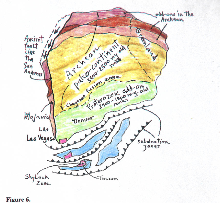
About 1,800-1,600 m.y. ago the lands of southwestern North America became added onto the old northern continent (called the Canadian shield proto-continent) in a process wherein several island masses collided in some way with the old continent, whose southern edge ran through what is now southern Wyoming. Note positions on the drawing of LA, Las Vegas, Tucson, each on a separate island. These were behaving much like New Zealand today - which is a chunk of continent which is adrift, having been ripped off of Indonesia (?) and is now adrift on its own and crossing the Pacific. Like continents, the island floats on dense mantle rocks, like a heavy battleship floats on water. With any luck New Zealand may eventually collide with Peru though right now it is stuck at a subduction zone and being pulled apart into two islands. It is NOT a Pacific Ocean volcanic island made of basalt like Tahiti or Hawaii, it is a lost chunk of continent. Similarly, in the North Atlantic off Great Britain lies a chunk of submerged continent called Rockall Bank (noted on Figure 7) that has already been drilled for petroleum exploration. It was once another British Isle halfway to Iceland but has fallen on hard times.
All of the collisions were with great force, enough to cause pressures and temperatures to rise enough to cause the parts to 'fuse' together - as seen in the top cross-section, a process akin to welding two steel plates together with a torch.
One particular welded zone from this ancient time can actually be easily seen, called the Shylock Zone, labeled on Figure 6. On I-17 north of Phoenix and south of Verde Valley lies the Sunset Point rest area for travelers, south of Cordes Junction. From the overlook there look west to the tall Bradshaw Mountains, which are made of Proterozoic rocks (granites, schists with many copper and gold mines) of one old island. But straight below where you stand (buried beneath recent lava flows) is another old island massif which collided with the Bradshaw massif, and the fusion zone is the darker-colored straight hill or ridge lying all along and in front of the Bradshaws - fairly easy to see (Figure 62). This ridge tracks northward out of sight as far north as Prescott, and to the south dives under the Phoenix valley. Note the cartoon geometry in the figure, how the two islands match up at the Shylock Zone.
The other mass labeled 'Mojavia' is a mystery. There are rocks of Archean age in Death Valley National Park (Panamint Range), an assembly called the World Beater complex, named for an insignificant mine operated by an optimist, the same age as old western Canadian rocks, that somehow got transposed into southern California. To view that problem go to the ghost town of Ballarat (westernmost Death Valley park on the Trona highway) and from the general store look up and NE into the rugged high country of the Panamints. No one can imagine how this juxtaposition happened - in the figure I show a slice of Archean rocks brought down along the old coastline. I'm allowed to move continents around like this because I'm a geologist and can think such thoughts.