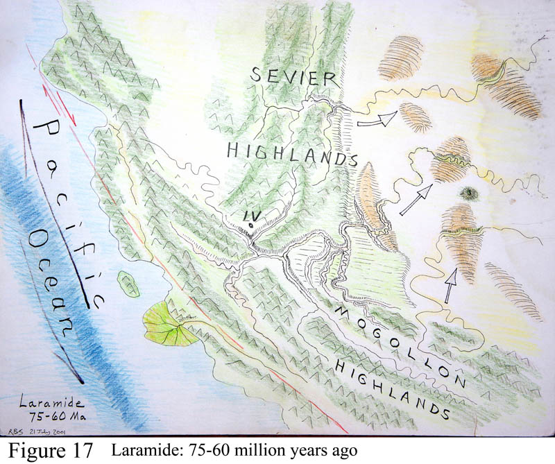
Southwest, Latest Cretaceous time
Figure 17. The Southwest in Latest Cretaceous time. The formation of the west coast batholiths was only a precursor to what happened next. The entire western region became involved in a major tumultuous geo-event called the 'Laramide Orogeny,' dated to about 75 to 50 m.y. ago - directly following the batholith age. An orogeny is a regional mountain-building event, usually accompanied by severe compression, volcanism, granite intrusions, and erosion off the highlands that forms thick sediment deposits adjacent to the mountains. The Laramide orogeny affected the entire western third of North America, but in addition strong volcanism at this time was felt all around the 'Pacific rim' from Indonesia through Japan and western North and South America. But in addition and for unknown reasons, some of the Laramide-age granite intrusions contained large quantities of valued ore minerals of copper-molybdenum-lead-zinc-silver-gold. Most of our big copper mines in Arizona (except Bisbee) are Laramide-age granites. Unlike the batholiths, gold was a minor component in Laramide ore deposits.
Figure 17 shows the land surface during Laramide time. Tucson is basically south of the letter 'D' in the word HIGHLANDS, nearly off the map. LV on the map = Las Vegas. Where the ancient river delta dumps into the Pacific Ocean (colored lime-green) is about where Los Angeles now sits.
Note two long bands of mountains. Highlands and mountain chains of the Mogollon highlands extended through southern Arizona, trending NW and SE. The remnants of one of these mountain cores can still be sensed at the place called Apache Pass (cutoff road just north of Chiricahua NM), seen at the parking area for the walk into historical Fort Bowie NM. Look for many kinds of rocks pushed together. Farther north on the map the Sevier Highlands was a north-to-south series of parallel mountain ranges through western Utah and north from there, caused by a powerful pulse of pushing from the west. In the upper right corner of the map are a series of individual rounded oval hills that looked strange at the surface, and colored tan on the diagram. These were a series of pushed-up arched domes now called Colorado Plateau domes and monoclines that are still present in the region. The one nearest to Las Vegas of Figure 17 is called the Kaibab arch or dome, and is now cut through by the Grand Canyon. In fact along the south side Grand Canyon tourist route road, you stand on top of that arch at an elevation of 7,000 ft. The highest point of that arch is across the canyon and north of the north rim viewpoints, at 9,000 ft elevation.
All these mountain chains and arches were made by immense push-together compression of the continental crust in Laramide time--but there is a BIG problem with the Laramide--that there was no continent off our west coast to collide with at the time. So what did North America hit? It was like a collision with things down below. And how else can such mountains be made? Fundamentally, geologists cannot explain away the Laramide orogeny, no matter how hard they try. But the processes included the production of all our major copper deposits. A mystery here, yes?
Another major feature of the Laramide was that the extreme conditions of the time produced a whole bunch of major whopping big-time super-volcanoes. Volcanoes come in three sizes of eruptive strengths - babies, mamas and papas. A baby-force eruption is like Hawaii where you can stand safely on the lip of the crater and enjoy the hot lava fountain (unless you're downwind). But to be anywhere near a mama during eruption, like Mt. St. Helens or Vesuvius, Etna, Pinatubo, Galagos, El Chichon, you're taking your life in your hands. St. Helens killed 57 people in May 1980 after they were warned of the danger.
Papa Volcanoes. And then there's the papas, the supervolcanoes. Modern humankind has never seen a papa eruption. The eruption of Thera (Santorini) in the Aegean at 1500 BC was a papa that got written up in the Biblical Old Testaments, in Genesis. Yellowstone is a papa, having erupted thrice in the past 2.2 m.y. and perhaps getting ready again. (New announcement, May 2015: we just found a second bigger magma chamber buried beneath the near-surface one. The USGS says to not worry, yet.) Other young papas in the U.S. are Long Valley (Mammoth California near Bishop, 730,000 years ago), and Valles (west of Los Alamos, New Mexico, near Santa Fe, about 600,000 years ago). But still these are smaller papas. The biggest eruptions in our recent past are Krakatoa and Tambora, Indonesia (1814, 1882, both mamas) that cause climate cooling for a few years. Still farther back was Toba, Indonesia, 75,000 years ago, a small papa that may have significantly reduced human population worldwide because of cool weather and lack of food.
Papa eruptions produce tremendous steam-blast columns of hot dusty smoke that may rise to 120,000 feet and then mushroom outwards (jets cruise at 30,000 ft). Finer dust particles may stay aloft for five years, keeping sunlight out and dropping the temperature significantly (10 deg F?). But the immediate local danger during eruption comes as thicker parts of the cloud sink back to the ground and blow outwards at 100+ mph for distances as great as 80 miles, called a pyroclastic cloud or flow, destroying all life in their path with a temperature of 700-1,200 + degrees F. These eruptions are associated with a kind of volcanic rock called rhyolite, a viscous magma that interacts with groundwater to form great explosions. (Rhyolite has more silica, sodium and potassium and less iron and magnesium than basalt.) At the end of a papa eruption the land over the magma chamber typically subsides and collapses into a broad circular valley called a caldera. The Yellowstone caldera valley is nearly 50 miles across. Toba's caldera is 65 miles wide. Long Valley's is 10 x 15 miles and Valles about the same size. The town of Los Alamos and Bandelier National Monument both sit on pyroclastic flows that blew eastward from Valles. The Natives at Bandelier carved caves into the soft cliffs of ash flow.
The Laramide orogeny seems to have produced many dozens of papa eruptions around the entire Pacific Ocean basin. The one in southern Arizona that I have studied is the Tucson Mountain volcano. Nearly all of the skyline of the Tucson Mountains is but a part of the southern flank of the volcano whose center is north of the visitor center of Saguaro Park west, and whose southern flank stretches southward to San Xavier mission. Its northern flank is buried beneath Marana. You can measure the diameter of the volcano as about 30 miles on Figure 19. Figure 22 is a cross-section of the eruptive event. Most of the volcano is buried under Tucson and Avra Valleys. Rhyolite flows from this vent, or another closely associated invisible sister vent make up most of the Roskruge Mts (north of Kitt Peak). The figure shows speculative extents of three or four Laramide-age 'sister' volcanoes in the immediate Tucson area including in the Silverbell Mts and the northern Santa Rita Mts. They are all mostly eroded away. The granite masses shown in red on the figure filled the volcanic vents. The granite at the north end of the Tucson Mountains is very visible at the Sus picnic area. With diligence you can put your finger on the edge of the vent itself, where granites contact older Paleozoic limestone rocks that formed the wall of the vent.
Another feature of the Laramide - conjectural, but I think a very good guess--that geologists recognize this time at 65 m.y. ago (end of the Cretaceous period, beginning of the Cenozoic era) as a time of a major mass extinction of life on Earth, about 70% of all species dying off. While a proven major asteroid strike in the Yucatan peninsula (a rock six miles across hitting at 40,000 miles per hour) certainly caused tsunami damage around the Atlantic Ocean basin (and another even-larger strike at the same time did likewise in India and environs); still the finger of suspicion for the major cause of the extinction, in my book, lay with the dozens of Laramide supervolcano eruptions with their potentially fatal atmospheric pollution effects. Some hard evidence places the very last two dinosaur extinctions (Tyranosaurus rex and Stegosaurus) at a mere one to two hundred thousand years BEFORE the Yucatan strike. Whoops--effect before cause. Volcanism around the Pacific rim was more likely the major factor in the extinctions, including the Tucson mountain supervolcano.