Figure 29. Temperature and Climate History
Thick books could be (and continue to be) written about our climate and its changes. A few bare-bone statements will be made concerning this favorite subject of mine.
Geological knowledge of the recent Ice Ages is a key input into how variable the planetary climate can be, as we search for natural control mechanisms. Is not the future guided by the past? It is curious that in ALL OF EARTH HISTORY there is evidence for some six or eight glacial epochs - the process seems not so common through geologic time, far less than 1% of our past. The long-ago glacial time called 'Snowball Earth' was mentioned in Figures 6 & 7, which seems to have dwarfed our current flip-flopping glacial conditions in magnitude, duration, severity.
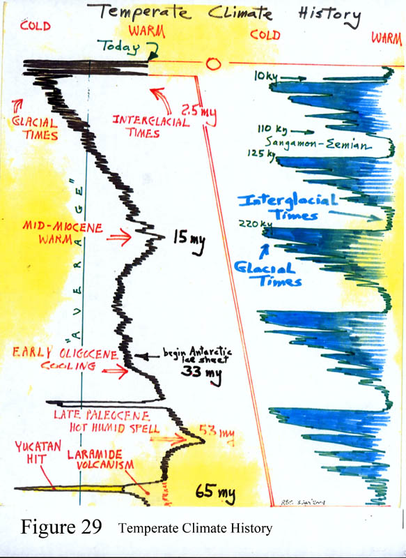
The left-hand column of Figure 29 attempts to illustrate the variation in mean surface temperature on Earth since the time of dinosaur extinction, 65 m.y. ago, colder to the left, warmer to the right. Some hypothetical 'average' temperature line is shown, whatever that means. Laramide-age volcanism (noted) produced cooling with its megatons of stratospheric volcanic dust, and there is evidence for limited glaciation at the time. The 'humid spell' at 50 m.y. is noted - described with Figure 20. The first evidence of glaciation on Antarctica shows up at 33 m.y., but it may not have been continuous since then. Following a warm period at about 15 m.y., the average temperature has been cooling. Then the first signs of mountain glaciers at mid-latitudes appears on land, at about 2.5 m.y.. And since then, many repeated cold times and new glacial events are obvious to the trained eye. Evidence for mountain glaciers include 'U'-shaped valleys with cirque depressions at their heads, lateral and terminal moraines (piles of unsorted bouldery debris pushed aside by advancing ice), and sharp craggy ridges between valleys called arêtes. Glacial outwash deposits of alluvium and loess plains (fine sand, silt and clay) washed and blown by the wind accumulate in downwind wide expanses like across the Great Plains region, the dust blown south from the katabatic winds blowing off the big ice sheet.
A hundred years ago geologists began to recognize worldwide evidence (first in Europe) that glacial periods have been episodic, and soon the overall glacial time became known as the Pleistocene period in geological terms. I have stood upon this oldest evidence of Pleistocene glaciation on land anywhere, contemplating the problem. It is a ground moraine (called a till) that sits in an unusual place - an unkempt bouldery layer atop McGee Mountain, which happens to sit directly adjacent to the caldera of Long Valley California, just east of the popular Mammoth Lakes ski resort north of Bishop. (This eruption mentioned in papa volcano discussion in Figure 17.) Highway 395 passes just to the north of McGee Mountain, and Convict Lake occupies the next canyon to the west of the mountain. This till was produced at about 2.5 m.y. ago, LONG BEFORE the volcano erupted at 730,000 years ago and the caldera valley collapsed, so that the old valley surface with a glacial till atop it sits on a tall mountain above the collapsed caldera floor.
Workers have refined their observations around the world, and now the best evidence tells us there have been 15-25 OR MORE times of glaciation within the Pleistocene period. 32 separate Pleistocene-age glacial cycles are recorded in the Czech Republic. Much work on many fronts have refined our knowledge of the temperature record, and now we recognize that a grand cycling of glacial events re-occurs about once per 100,000 years, as seen in the right hand column of Figure 29. (Ages in the column are in 'ky', meaning thousands of years; 10 ky is 10,000 years.) It is amazing that this glacial cycle time was first predicted by a Serbian mathematician named Milankovitch in the 1920s who hand-calculated the effect of Earth's three main orbital variations, and so in his honor these are called Milankovitch cycles. The cycles include processional wobbling (spinning top effect) and variation in shape of the orbit from circular to elliptical, taking into account that 90% of all land is north of the equator--land absorbs sunlight and warms the atmosphere; water reflects 85% back into space.) The net effect is a 100,000-year global temperature cycle. The evidence for all this comes from the study of ice cores in Antarctica and Greenland and various cave deposits of limestone and some seabed muds that hold chemical and isotope markers of temperature change. A major 400,000 year-long temperature record is recovered from cave deposits at Devil's Hole, near Death Valley, studied by a friend of mine, Isaac Winograd.
The bottom line for recent past climate behavior is that there seems to be a shorter period of present-day climate like in the past 10,000 years and then the gradual buildup of ice in higher elevations and latitudes in a flip-flop cycling, glaciers increasing in magnitude, and finally a massive glacial time in a 100,000 year-long cycle. The last major warm time is called the Sangamon interglacial, some 110,000 years ago (labeled in the figure). The last major ice time peaked at about 23,000 years ago, then serious melting is seen at about 16,000 years ago, with the meltback volumes declining in magnitude by about 11,000 years ago, at which time the climate became modern, and our Sonoran Desert and temperate forested areas were born. (Therefore, according to the figure, the next glacial time is about due to begin - we've exceeded the 10,000 year average.) During this last major glacial time, called the Wisconsin glaciation, the Laurentide ice sheet grew to massive proportions, outsizing the Greenland cap and became centered over Hudson Bay Canada where it was 2+ miles thick, and it reached south to cover Boston, New York, and came up just short of St. Louis Missouri. A lesser ice cap formed contemporaneously in British Columbia-Alaska, called the Cordilleran ice cap. Europe of course was quite icy - Britain under ice. All that ice on land including Siberia lowered sea level by about 400 feet. If all the remaining ice were to melt sea level would rise another 100 feet. So about 20% of all the ice of the ice times is still here. All the western mountain above about 9,000 ft elevation had permanent ice or glaciers. There were mountain glaciers everywhere in the Rockies and Sierra Nevadas, and in Arizona upon San Francisco Peaks and Mt. Baldy in the White Mountains. Please to visit Rocky Mountain National Park above Denver, or stand atop Independence Pass east of Aspen along highway 82 (elev 12,095 ft), and quite near to Mt. Elbert (Colorado's highest, 14,433 ft) to view the effects of mountain glaciation where it carved out deep 'U'-shaped valleys. There were actual ice caps on top the Wind River Mountains of Wyoming and several of Utah's high plateaus--and the Wind River cap is still there--some 20 square miles of ice, and half melts into the Green River basin! I have found evidence for permanent ice in a canyon above the ski area on Mt. Lemmon in the Catalinas - a minor effect called protalus ramparts, a deposit of rocks and boulders crossing a canyon, deposited there as they slid down from cliffs above a steep ice mass and collected as debris at the base crossing the valley. The temperature was cooler enough that all trees in our region grew at 3,000 ft lower elevation, so that Tucson Valley was probably covered with an oak-juniper grassland and ponderosas grew along Sabino Creek. The Yuma Mountains harbored juniper trees. Timberline in the West dropped by 3,000 feet.
Climate modelers go crazy trying to see how the cycling works, and then Congress goes crazier-still listening to them and their fancy charts in six vivid colors showing crazy-wild and sudden variations. There HAVE TO BE major changes in circulation in the atmosphere, the jet stream, and in the major oceanic 'conveyor belt' warm currents. The real issue of how Nature initiates a glacial time is totally counterintuitive - that somehow there must be much more heat concentrated in the low latitudes than at present to evaporate much more water. This great excess of water vapor (over current levels) then must have tracked northward to cause much greater snowfalls in the high latitudes. Thick snow cover reflects sunlight back into space, and the northlands then refrigerate significantly as heavy snows continue for a LONG time, while the equatorial zone must remain very warm. If the equator cools, major snowfalls in the north cease and the ice cap stagnates. Throw in the effect of global warming due to anthropogenic CO2 additions, and the models become practically bizarre. If the oceanic bottom waters warm a little, then a significant 'methane ice' or clatharate layer that lays buried in many places on the seafloor can melt, which adds methane to the atmosphere that converts quickly to more CO2--a runaway effect. Some models say that the current warming will hasten the next ice age because heating causes evaporation that causes snows that drive the climate changeover. By the way, global warming cannot just continue on because of a major condition on Earth - our great water oceans will absorb the heat effectively and evaporate faster, countering the heating effect in the long run. All the excess heat merely drives the production of storminess & snow.
But also the models say that for complex reasons continental interiors and desert-like areas will dry out more as storms divert to elsewhere, such as coastal regions and mountains and into higher latitudes. This year (winter of 2014-15) saw 40-60% or more reduced snowpack compared to 'normal' in the Rockies and High Sierras, while the U.S. east coast got blasted with near-record snows because the polar vortex slipped sideways. And so Governor Jerry Brown of California has instituted water measures for the drought, including building two coffer dams on the Sacramento River near San Francisco to keep salt water from San Francisco Bay from flooding upstream and destroying valuable farm land - because the river is effectively dry. As well, it seems too early to tell about future monsoon seasons that are caused by Atlantic hurricanes from off Africa and the seasonal Bermuda high pressure cell that pushes moisture westward, to give the Sonoran Desert its July-September thunderstorms.
The next issue is the actual cause of the Pleistocene glaciation. Note in the left column of Fig 29 that the world's mean temperature has been dropping for the last 15 m.y., but well-recorded glacial cycles are only found for the past 2.5 m.y.. What is causing this long-term cooling? A major suspect is the strength of heat from the sun. It is a factoid that has NOT gone un-noticed by the modelers that there was a brief return to icy conditions during about AD 1620 to 1720 (felt and recorded in Europe and North America), called the 'Little Ice Age.' The French wine harvests failed miserably, leading to political upheavals. Turns out this time coincided with a period when the sun decided to practically cancel its sunspot cycle. These little dark spots on the sun are where cooler gases convect back down into the photosphere. You can see them (quite safely) without a telescope or dark glasses--a pinhole camera projecting the image into a cardboard box painted black inside. Modern measurements can find very little variation in solar brightness over an entire sunspot cycle (a new measure says maybe 0.1% reduction in brightness during sunspot maximum) - but how much difference does it take to affect Earth? No one knows.
Hot off the press--a new paper as of May 2015 indicates a relationship between climate oscillations and rates of basalt formation at a spreading center south of Australia, but the direction of cause and effect is not clear. Since volcanism ejects greenhouse CO2 into the atmosphere, there may be a hidden relationship. Increased rate of volcanism at spreading centers may be caused by lesser water pressure due to shallower seawater depths during glacial times.
We are the fleas on the back of the climatic elephant, bouncing along for the ride. We adapt to the changes, and suffer the consequences.
The next surprise. Another condition of the glacial cycle has most assuredly affected humankind's history to a degree that so far has been basically ignored in many ways by mainstream historians and archaeologists. 23,000 years ago, sea level was lower by ~400 feet, and the world's climate was far cooler in temperate regions by some 6-10 deg F, while the equatorial regions must have been quite warm in order to feed the moisture for all the snows. There is always a high seaside population, towns, cities, ports, docks, temples. More people probably lived at low latitudes, with a far greater temperature gradient between the equator and the poles. The best guess of how people survived the ice age is that they crowded into the tropics and lived at more northern latitudes along coastlines as fishermen where seawater temperatures moderated the cold interiors. But now reports are flooding in (a pun) that there are many offshore villages, temples, towns and human habitation sites found underwater in hundreds of scattered places - throughout the Mediterranean, off India, Japan, Indonesia, and in the Pacific and Atlantic provinces. What prehistoric cultures were these? They are totally unknown in history. The 'beginning' of civilization as we know it - Sumeria, Mesopotamia, the old Egyptian and Chinese dynasties, the Jomon of Japan with the oldest pottery, these were all developed in the past 6,000 years (Jomon perhaps older). These buried coastal sites are all older than about 8-10 thousand years. There is a large flooded docking facility made of megatons of big stone blocks offshore of Bimini in the Bahamas. There seems to be a temple complex buried off the west coast of Cuba under 2,200 feet of water, but its burial likely due to both tectonic dropping and sea level rise. Who built it? We are just discovering megalithic hilltop stone temples with 'T'-shaped lentils at Gobekli Tepe Turkey and in Syria with 20-ton stone blocks, dated at 10,500 BP, six thousand years before Sumeria. The Egyptian process of mummification was apparently borrowed from some South American culture of Peru-Chile who practiced it at least 3,000 years prior, including the ritual use of tobacco and coco leaf products and the same kind of cotton wrappings; and recently announced was the world's oldest pottery in human context, found in central Amazonia, 10,500 BP, which at the time may have been a vast savannah. Many forward-looking authors are asking if this quick climate warming at some 12-9 thousand years ago that flooded coastal habitation sites may be the 'great flood' that is described in old literature worldwide, including Middle Eastern sources like the Babylonian epic of Gilgamesh written prior to a thousand years before oldest Biblical accounts. Just how well do we understand our ancient origins, considering that we have knowingly burned the vast bulk of our written records? Francis Drake was knighted by Elizabeth for burning the best sailing library of the time at Cape St. Vincent Portugal built by Prince Henry the Navigator - because Elizabeth didn't like his father King Joao. You want a true unexplained anomaly? - research what Charles Hapgood said about the Piri Reis map, that according to the office of U.S. Naval Research shows the coastline of Antarctica unglaciated, and drawn before 1400 AD.
Or, along a different line, just ask, how did our ancestors survive the repeated ice times?
There is another fascinating subject that somehow is unsavory to American archaeologists, for unfathomable reasons - the time of first appearance of mankind in the New World. The subject is fraught with minefields of disinformation and character assassination, fueled in part by bogus claims. So do we harvest the wheat, or throw it out with the chaff? There is tenuous though valid evidence that Homo erectus made it to the Americas, at least 250,000 years ago. Two sites are known to me - Calico Hills near Barstow CA, and Vasequillo Reservoir near Mexico City. I have examined Calico closely. See the Chris Hardaker book in the references.
We are all a product of our past, but with our march poorly recorded. We--all life on Earth--actually owe our very existence to a massive continuous thermonuclear explosion in a star that eats 400 million tons of ionized hydrogen per second and in that time looses 4 million tons of mass, converted to light in the way Einstein predicted. Then 8.3 minutes later that light bathes and warms Earth. Its been behaving this way, more or less, for the past 4,600 million years. So, please enjoy your lattes and backyard barbeques. Wax your skis, pack your snow shovels, chop your wood, and watch the weather.