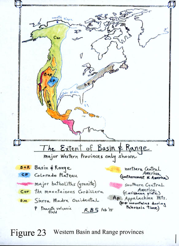
Figures 23, 24, 25, 26. Basin and Range Development.
The of North America is unique in the world, and therefore is due to some very unusual circumstances. Its size is impressive, shown on Figure 23. Some geologists (like myself) show some submerged below the Pacific immediately offshore in southern California and Baja. Some maps stop the province at Idaho's Snake River plain, while others, like myself, extend it north a few hundred miles farther into British Columbia because it is really there.
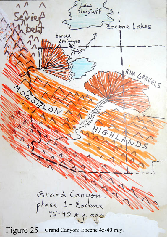
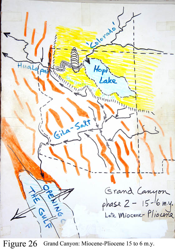
The common element to this land is the resounding presences of hundreds of long narrow mountain ranges lying more-or-less in parallel, and oriented more-or-less north-to-south, and separated by broad flat valleys. In Arizona the range crests are spaced about 25 miles apart, and many valleys have 'dog-leg' bends in them (see Figure 30), while in Nevada mountains and valleys trend more straight-line, and adjacent ranges are separate by about 40 miles. The valleys in Nevada and California are not so flat, more narrow-appearing and deep, and the mountains higher above the valley floors, with sloping sides that meet at the center. Figures 25 and 26 show Arizona just before and just after pull-apart action.
The absolute best showcase view of the province, in all its glory, is to travel Nevada's highway 50, crossing east-west the 'great washboard' between Carson City and near to Salt Lake City. But I-8 between Casa Grande and Yuma also gets the point across. Also, though, you really MUST explore California's Mojave National Preserve (sitting between I-40 and I-15 east of Barstow) where is not just obvious, but imposing, grand, windy, and filled with Joshua trees. You may start at Baker, then find the refurbished Kelso train station and have a nice latte.
Scattered across the province, some valleys remain as closed basins where rain runoff has no choice but to flow inward to the valley low point, so that a playa lake forms that holds water following storm events. There are dozens of playa valleys like Willcox and Lordsburg, mostly in the Great Basin of Nevada-Utah-California. A few of the playas concentrate certain minerals of commercial importance like borax, lithium, soda ash and magnesium. A vast flat playa surface at Edwards air force base in California served as a landing field for the space shuttles (Edwards playa featured in the Hollywood movie The Right Stuff). Utah's Great Salt Lake is the wetted portion of a huge playa that during the Ice Ages held a lot of water, enough to cover a quarter of the state (see figure 27 and 33). To see the flats travel from Salt Lake City westward to Wendover. For a strange day trip while in Death Valley NP, travel to the Racetrack Playa and view gouged trails where rocks up to hundreds of pounds travel across the surface in the wintertimes, much to the chagrin of geologists. The desert winds are certainly involved, and now a movie has been made of a rock moving along on a breezy day.
All available evidence points to a two-part history of the . First, mountain-valley structure is developed precisely where there was vigorous mama and papa volcanic action, see Cenozoic volcanism in Arizona. All the big papa volcanic centers are found in country. The big heating responsible for the scores of big papas was also responsible for what happened next.
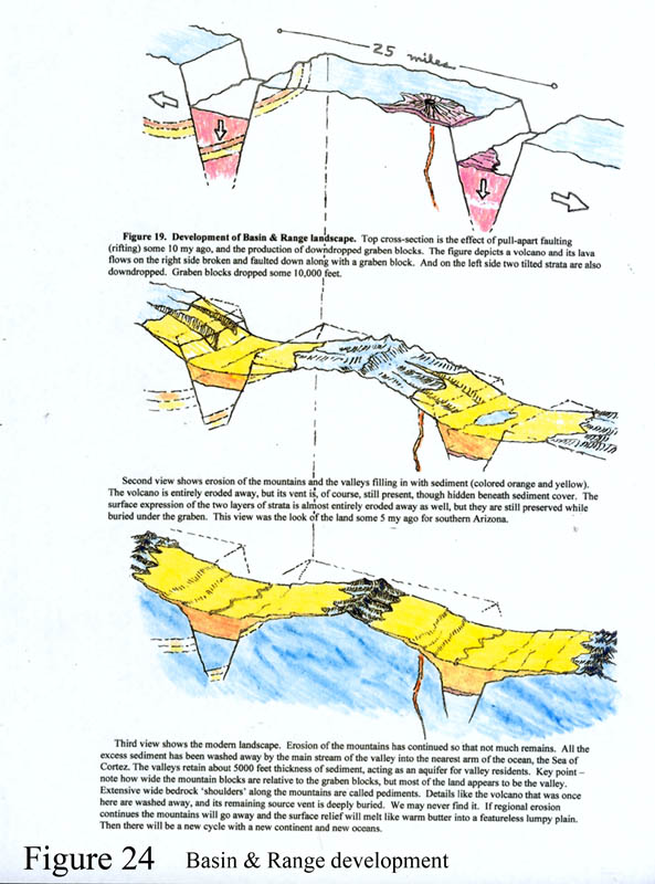
The primary production of the mountain-valley structure of is certainly due to a powerful pull-apart of the crust because there are pull-apart faults at the base of all ranges. We figure that all the volcanism heated the crust to such an extent that when a pull-apart force underneath acted, the crust yielded, mostly by a taffy-pull effect. But the cold surface rocks broke apart - shattered - like a pane of glass dropped onto the pavement. The best analogy possible could be to take a hard chocolate-coated caramel candy between your fingers and crush it and pull it apart. The caramel flows easy while the hard chocolate surface layer breaks into pieces that move along sideways during the pull-apart. Then you may eat the candy.
The process of pull-apart faulting is called 'rifting', and the downdropped blocks are called graben blocks. The blocks that retain some original height are called horst blocks. Such single graben valleys are common worldwide, like the Rhine River valley or the east African rift valleys or the valley of Lake Baikal in Russia. The Dead Sea valley of the Levant is also a modified rift but it is also a developing plate boundary. But in our region rifting occurred continuously over a large region, a distance of 800 miles east-to-west, and 2500 miles north-to-south. Somehow, a huge mass of hot upper mantle rock mushroomed up at great depth across the region, first causing the volcanism, and then the stretching. The event occurred between about 15 and 5 m.y. ago - peaking at 10 m.y.. The magnitude of the taffy-pull was positively gargantuan - we calculate there was 100% pull-apart of the underlying taffy layer. So to deconstruct the motion (run time's movie backwards) you must move Salt Lake City (eastern edge of ) westward nearly half way to the Pacific coast - to where it sat before the stretching. stretching increased the land area of North America by some considerable bit.
If you travel I-10 east past El Paso, watch how the mountains just disappear east of the city. That is the boundary between and the Great Plains province. Another great view of this interface is at Cloudcroft New Mexico atop the Sacramento Mountains - the far eastern edge of . The Inn at Cloudcroft has a resident ghost, seen many times, whose statue greets you in the Fourier.
Harder to explain is that during development, 10 m.y. +/- years ago, the entire southern Rocky Mountains were uplifted to their modern status by a great amount for a third cycle. They form a very imposing boundary between the mountainous western lands and the Great Plains central region of the continent. I have never heard an explanation for this unusual act of nature, why stretching should cause the Rockies to uplift. A place to feel this stunning magnificence is the top of the drive through Rocky Mountain National Park, peering out to the very flat Great Plains to the east.
During the rifting process in , graben blocks dropped some 10,000 feet relative to the mountains. And then erosion off the adjacent mountains of rocks, sand, silt, and clay gradually buried the graben blocks under some 5,000 foot thickness of sediment. Mountain fronts became lined with cones of debris washed out of canyon, called alluvial fans. This is depicted in Figures 24 and 30. And then, typically, given how exposed rock disintegrates, most exposed mountain fronts wore away so that the exposed mountains became narrower and less tall. Ultimately, the mountains will dissolve into a state of no bedrock sticking above a bumpy alluvial plain--such is the power of erosion, a continual force on Earth. But in the meantime the original width of each mountain mass is converted into shallow-buried trimmed-off bedrock on either side. These buried bedrock 'shoulders' are called pediments, that sit adjacent to the mountain range and line both sides. Figure 24 attempts to show this kind of mountain-valley development.
Because significant groundwater accumulates only in the thick sediments above the graben blocks, anyone attempting to drill for water on the pediment portion of the valley will come up short. Note how the graben block typically occupies only the central quarter or so of the width of the valley. Many landowners have learned this lesson the hard way when their new $15,000 water well produces a half-gallon per minute.
Valleys that developed as a closed basin and that contained playa lakes may contain a surprise still. When they were closed basins they acted like a bathtub, so that waters flowing in usually contain dissolved salts like table salt (halite, NaCl) or gypsum (CaSO4), etc. When the water evaporates beds of 'evaporite' salts are left behind. The waters in the deeper parts of the basin become very saline as the salts re-dissolve. Only the near-surface waters are more fresh. This situation limits the amount of drinkable groundwater to well less than developers would have us believe. Some places like Eloy Valley contain a staggering salt-gypsum bed of 50+ cubic miles! True! We've drilled holes through it.
country in California's Mojave Desert region (around Barstow) presents unique challenges. It lacks the simple parallelism in mountain alignments, and is caught between two major active fault systems, the San Andreas to the SW and the Garlock-Death Valley system to the east and north. Death Valley's floor at 280 ft below sea level is still actively sinking, and wet times wash large amounts of debris onto 15-mile long alluvial fans coming off the Panamint Mts on the west side, while wholesale blocks of rock cave into the valley off the Black Mountains on the east side, called 'turtleback' faulting.
Figure 30, a geologic map, indicates the size and shape of the graben blocks in SE Arizona.