Cabeza Prieta Natural History Association
A Visitor's Guide to El Camino del Diablo
Leg 2b: El Camino del Diablo from Tule Well to Tinajas Altas
 Mile 69.0. 32°13'35"N, 113°44'59"W. Key Junction, Tule Well. At the junction head west (left) to go to Tinajas Altas.
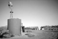
Tule Well has a cabin, well, large water tank, and picnic tables. The current cabin was built in 1989 by the US Air Force's 832nd Civil Engineering Squadron to help celebrate the refuge's 50th anniversary, and it replaced an earlier cabin built in 1949 for refuge staff, livestock line-riders, and border agents. Traces of the old well are visible. The campground has several picnic tables. The flagpole and Boy Scout monument northwest of the cabin were built for the refuge's dedication in March 1941 and enhanced in 1989. The original plan was to place a life-sized statue of a bighorn sheep on the monument's base. The scouts were instrumental in a political campaign to establish the refuge.
 The original hand-dug well was not there at the time of the Gadsden Purchase and subsequent boundary survey of 1854, nor did Pumpelly mention a well when he passed this way in 1861. But the boundary surveyors of 1891-1896 reported, "During the 'early sixties' [1860s] there was a large influx in Mexicans from Sonora to the gold diggings on the Colorado River, and an enterprising Mexican dug two wells near the road, in the purpose of selling water to travelers. But the deaths from thirst along this route became so frequent that the road was soon abandoned and for over twenty years had remained unused." By another account, perhaps apocryphal, the enterprising Mexican who dug the wells was killed by someone who refused to pay for water.
The 1890s surveyors hired a party of workers from Sonoyta to clean out the wells, which had nearly filled with dirt, and the wells then "yielded a supply of about 500 gallons per day. The water is beautifully clean, but owing to the presence of minerals has a vile taste and is very unwholesome. Near the wells stand the ruins of the old adobe house, the only building between Quitobaquito and the Colorado River." The wells first appeared on an 1894 General Land Office map.
The well or wells were about 35 feet deep and relied on a bucket and windlass to bring up water. Raphael Pumpelly traveled along the Camino del Diablo with his family in 1915, and the well left a lasting impression on them. He wrote,
"We camped at the abandoned Tule well. Its water was both brackish and offensive, but facing thirst on the desert one can't be squeamish. Several months later a friend who had been over that route on a survey asked: "How did you like the Tule well water?" "Not much," I answered. "Naturally," he said, "for we found and left a man in it two years ago."
Later a windmill raised water. Now it is a covered well with a solar pump and large storage tank. White salts on the soil indicate ground water close to surface, as do salt-tolerant plants such as seepweed (Suaeda nigra) and desert saltbush (Atriplex polycarpa). This is one of the few places along the Camino where these plants grow.
Mile 70.7. 32°13'11.7"N, 113°46'32.7"W. Note differences in color of sands in this small wash: blond from granite west of the wash, and black from basalts east of the wash. Also this is a favorite place to stop and touch the granite and wander among the small outcrops, especially for youngsters.
The first wash to the west has stands of sweetbush (Bebbia juncea var. aspera), a prolific producer of food favored by butterflies and chuckwallas, hence its other common names butterfly bush or chuckwalla delight. You may see chuckwallas (Sauromalus ater) (large herbivorous lizards) later at Tinajas Altas or along the route to Fortuna. The wash also features canyon ragweed (Ambrosia ambrosioides) and narrowleaf climbing milkweed (Funastrum hartwegii).
Mile 70.8. 32°13'12"N, 113°46'40"W. Administrative trail to north goes to Buckhorn Tank, a pleasant 2 ½ mile walk one-way. From the tank you may wish to walk to the low pass west of the tank and circle south around the mountain back to your vehicle. If flowers are blooming anywhere on the refuge, they usually are blooming along this route, plus you may see bighorn (Ovis canadensis mexicana), butterflies, and other amazing creatures along the way.
Buckhorn Tank was an intermittent tinaja used by Native people, and then enlarged by the refuge as a waterhole for wildlife in 1948. Named by refuge patrolman John "Ace" Kempton for horns and skeletons of desert bighorn sheep he found in the area. After a week's stay in an observation blind at the tank, naturalist Ann Zwinger wrote, "Easy landscapes stifle me.... I prefer the absences and big empties.... I prefer the raw edges and the unfinished hems of the desert landscape."
Also, you have a good view of Cabeza Prieta Peak from this road junction. Many people looking to climb the peak start their trek from here. It's a full day venture, about 6 miles each way, much of it across rough ground. The vistas are stunning.
Mile 70.9. 32°13'12.0"N, 113°46'49.9"W. Border Patrol roads to the south and north are closed to the public.
As you go.... Miles 71.0 to 73.8: Good examples of dark cryptobiotic soil crusts carpeting ground between creosotes. Following summer rains, these carpets may erupt with hundreds of millipedes that live underground most of their lives but graze on the living crust, primarily at night.
Tire tracks across the soil may be decades old and are harmful to the soil because tires kill the crust, compact the ground and reduce moisture, create erosion, and encourage other misguided drivers to follow off-road. Driving off-road also attracts the attention of police who may assume the driver is a smuggler.
 Mile 71.6. 32°13'12"N, 113°47'34.8"W. Tule Tank. This famous tinaja about ½ mile north of the road was a crucial water stop on El Camino del Diablo. In 1925 hydrologist Kirk Bryan reported, it can be found "1,600 feet...up a narrow canyon. It consists of a rock basin about 6 ft. in diameter at base of dry falls and is usually full of sand. Water is found in the sand for some time after rains. Not permanent."
 Rock basins such as this were extremely important sources of water for Native people and early European explorers. They are called "tinajas" in Spanish. Carl Lumholtz, an intrepid Norwegian ethnographer who traveled the Camino in the early 1900s, writes the following about Tule Tank, "At Tinaja del Tule...we watered our animals and filled our barrels." He goes on to comment that he was surprised at the small volume of the water hole, but then says, "Still, as it is in sand, it contains somewhat more water than is apparent, and it would cover a horse standing in it." Kirk Bryan reported that a sand-filled tinaja may hold about 25% water in the spaces between sand grains, and you may see holes where wildlife, especially coyotes (Canis latrans mearnsi), digs for water. Evaporation from open water surfaces may reach 1 inch per day, with Yuma running about 120 inches per year.
Tule is Spanish for "cattail" (Typha domingensis) and its O'odham name 'U?uvhag ('Uduvak) means "where cattails grow." No cattails grow here today, but the canyon is a pleasant place to meet hollyleaf bursage (Ambrosia ilicifolia) and to see grinding holes used by Native Americans. The presence of grinding holes (known as mortar holes to archaeologists), provides a glimpse into the life of the Native people who lived in the region. With heavy stone pestles, they ground mesquite pods into meal in these holes, which are found near virtually all tinajas.
Along the wash you may be caught by the thorny catclaw acacia (now Senegalia greggii), a fragrant blooming tree that attracts numerous native bees. The range of this tree is a bit unusual, for it grows in a belt across the US-Mexico border states and Nevada from the Gulf of Mexico nearly to the Pacific Ocean. A very small butterfly may be encountered at the flowers, the Marine Blue (Leptotes marina). The tinaja is at 32°13'35"N, 113°47'47"W.
As you go.... Miles 72.3 to 72.7: Rocks to scamper on! Look for unusual plants among the rocks, such as ragged rock-flower (Crossosoma bigelovii), turpentine broom (Thamnosma montana), California otat (Fagonia californica), and desert-fir (Peucephyllum schottii), as well as bighorn tracks, scat, and beds.
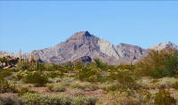 Mile 74.0. 32°14'14.8"N, 113°49'36.4"W. This is a pleasant spot to rest and take flower photos, and a good starting point for those wishing to hike to Cabeza Prieta Peak, about 3½ miles one way. The summit, one of highest in the refuge, offers a stunning panoramic view of the refuge and beyond. The peak's Spanish name means "dark head," and in O'odham it is S-Chuk Mo'o ("black head"). The seldom visited Tule Mountains stand to the south.
Many of the surrounding mountains are light-colored granite covered by a layer of dark basalt, but most of the basalt has been eroded away.
As you go.... Miles 75.5 to 77.1: Watch for bighorn tracks crossing road from one mountain to another, or feeding on new growth of trees along the washes. Seasonal devil's claw (Proboscidea altheifolia) and globemallows (Sphaeralcea coulteri) flower here.
Leaf-cutter ants (Acromyrmex) may leave trails of leaves and petals across the roadway as they take them to their nests marked by entrances shaped like miniature volcanoes. In their underground vaults, the ants actively farm fungus on the organic matter, and that is their food. Individual colonies may be many decades old and even use the same entrance; these nests may extend 10 to 12 feet below ground. You may see harvester ants (such as Pogonomyrmex, Messor, or Aphaenogaster) that gather seeds, bring them back to the nest, and crush them with powerful jaws. Harvester ant nests are characterized by denuded ground around the entrance and piles of chaff. Ants and termites are major agents in aerating the soil and recycling organic nutrients. Some experts estimate that the biomass of ants and termites exceeds the living weights of all other animals in the desert combined. They do the work done by earthworms in moister climates.
Mile 76.1. 32°14'52.0"N, 113°52'03.1"W. These slopes are like gardens. Note desert tree-beargrass (Nolina bigelovii), desert agave (Agave deserti var. simplex), and elephant trees (Bursera microphylla) on the slope, where you'll also probably find ragged rock-flower (Crossosoma bigelovii), twinberry (Menodora scabra), arrow-leaf (Pleurocoronis pluriseta) and other uncommon desert plants. In Spanish the Agave deserti is called lechuguilla, giving its name to the Lechuguilla Valley just ahead.
Mile 76.6. 32°14'49.4"N, 113°52'58.9"W. You are leaving the granite mountains to cross the Lechuguilla Valley, but may find a suitable campsite here.
The Tinajas Altas Mountains appear low on the western horizon, almost like a mirage. If you are a thirsty traveler on your way to the gold fields of California, can you find the next waterhole? Can you walk that far? You've still got about 12 miles to go across the Lechugilla Desert before you can get water at Tinajas Altas -- if you can find them, and if there's any water left. If you found water a few miles back at Tule Tank you're probably feeling confident. If you didn't, you've now come across more than 50 miles of waterless desert and could very well be at the edge of your endurance.
Earliest travelers didn't have the information we do today. There were no guidebooks, no road signs, no GPS, and no satellite imagery. At best they might have a very crude map (though we know of no surviving examples), and they were probably finding their way based on verbal directions provided by someone who may or may not have actually done the trip. One survivor of the Camino, Raphael Pumpelly, got his directions in a saloon from a bandit who intended to waylay him. A typical set of directions might have told you to ride west for a day to a white pass, then up a canyon to find water, then ride another day to a broad valley, then veer north, and so on. What's amazing is that many more people didn't die, and it says a lot for the hardiness and determination of the many people who have passed through here.
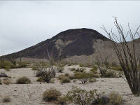 Mile 77.1. 32°15'06.9"N, 113°52'35.4"W. Tordillo Mountain (2,170 ft.) to your north provides an interesting hike and scramble. Tordillo means "dappled" or "gray." Tordillo and Cabeza Prieta Peak are on the eastern side of a large granite batholith that includes the southern Copper and Gila mountains, plus all of the Butler and Tinajas Altas mountains. The rock, intruded in Cretaceous or Paleocene times, is called Gunnery Range granite in a salute to the Goldwater Range. The basalt caps on Tordillo, Cabeza Prieta Peak, and Raven Butte came later (16 to 10 million years ago).
As you go.... Miles 77.2 to 77.5: A rough stretch of road across the lava from the Tule Mountains reminds us why the old Camino del Diablo was primarily a foot or horse trail.
Leading a survey team in 1855, Lt. N. Michler recalled, "Imagination cannot picture a more dreary, sterile country, and we named it the 'Mal Pais'." Bad country.
Mile 77.5. You are now atop a hill and can see the long, straight trail to Tinajas Altas. One witness, Lt. N. Michler in 1855, reported somberly, "All traces of the road are sometimes erased by the high winds sweeping the unstable soil before them, but death has strewn a continuous line of bleached bones and withered carcasses of horses and cattle, as monuments to mark the way."
In addition to obvious brittlebush (Encelia farinosa) and creosote (Larrea tridentata), look for beavertail cactus (Opuntia basilaris) and many-headed barrel cactus (Echinocactus polycephalus), both preferring very hot and dry homes. If you've seen the many-headed barrel in bloom, you've been here in the heat of June.
 Mile 77.9. 32°15'24"N, 113°53'21"W. Parking for an easy walk of about ½ mile south to the Grave of Eight. The spot is also about 8 miles from Tinajas Altas and slightly more than 8 miles back to Tule Tank.
In 1896 surveyor and soldier David D. Gaillard reported that "an entire Mexican family of six or eight persons" had the calamity of its glass demijohn of water breaking about eight miles east of Tinajas Altas; all perished and the site is now commonly known as the Grave of Eight. "The wagon tracks made when the [unfortunate] Mexican drove his exhausted team to one side of the road, were plainly visible thirty years afterward...."
Gaillard reminded his readers, "Nor are these horrible experiences confined to the past alone. The desert still claims its victims, and not a month passes but that some inexperienced prospector yields up his life in the search for the fabled mines of the desert-sirens which have lured scores of victims to their deaths. On two different occasions prospectors were rescued by our own [survey] parties when death seemed to them to be inevitable."
But disregarding the desert's perils, Gaillard fell in love with it. "In spite of all that has been said, there is an unexplainable fascination about the desert -- a charm which, after a while, everyone feels, and which causes one to look with longing for the time when once more his eyes may rest upon the well-remembered scenes, and once more he may stand amid that weird, appalling -- but now to him soothing -- silence."
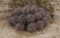 Mile 78.9. 32°15'43.9"N, 113°54'17.1"W. A many-headed barrel cactus (Echinocactus polycephalus) north of road. This one has 27 heads, which are really stems of one cactus, not a cluster of individuals. Another cactus of this species at Mile 82.0 has 62 heads, and one in the area is reported have over 150 heads.
As you go.... Miles 79 to 81: The mountains south (left) of the road are Sierra Lechuguilla, that straddle the international borderline.
Mile 82.4. 32°16'55.7"N, 113°57'41.3"W. Western entrance to CPNWR. Visitor kiosk and Border Patrol turnaround. Camp if you wish -- the site is roomy.
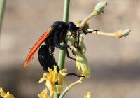 Note perennial giant sand milkweeds (Asclepias erosa) along the roadway; when in bloom they attract many pollinators, including Pepsis and Hemipepsis wasps. Too, you may spot dragonflies in the open desert many miles from the nearest standing water. For example, the rainpool gliders (a type of dragonfly) are a strong, wide-ranging genus (Pantala) that not only find distant pools in which to lay their eggs, but they may accompany humid weather-fronts and storms to lay eggs in ephemeral pools left by the newly fallen rain.
When you exit the refuge and drive west from here, you are in the Barry Mr. Goldwater Range-West controlled and administered by the US Marine Corps at Yuma. Just as Organ Pipe and the Cabeza Prieta have patrol rangers, the Goldwater Range has wardens assigned to protect the resources and assist the public. A current range permit and check-in are required for each visit.
Each road junction on the Goldwater Range is marked with a wooden 4 x 4 post bearing a letter and number. This is the name of that junction -- for example, A-4 -- and not the name of the road. (The Marines can provide a fine map showing each junction and road; pick it up with your permit if you're starting from Yuma.) If you see a spur road, but not a wooden post at the junction, that spur road is closed and should not be driven. This prohibition includes spur roads marked by small metal signs bearing the letter 'S' and a number (e.g., S55); these are military staging areas, not roads for public use.
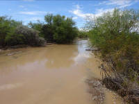 Mile 83.6. 32°17'19.5"N, 113°58'49"W. Head of Coyote Wash. Lush vegetation; the road may be impassible when flooded. The wash is hardly discernible, for runoff here is unchannelized sheet flow. Not far south from this point is a watershed divide with La Jolla Wash. Coyote Wash runs north to the Gila River, and La Jolla Wash runs south and soaks into the Gran Desierto sands.
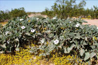 Botanist Richard Felger fondly remembers this place: "It is humid and warm and an aromatic yellow carpet of desert chinchweed (Pectis papposa) and other summer annuals almost completely covers the ground between the creosote bushes, mesquites, wolfberries (Lycium macrodon and L. parishii), desert saltbushes (Atriplex polycarpa), white bursages (Ambrosia dumosa), canyon ragweeds (ambrosia ambrosioides), brittlebushes (Encelia farinosa), and button encelia (Encelia frutescens). Half-grown sphinx-moth caterpillars graze on Boerhavia plants and there is a constant buzz of insects. The soil is glistening mud made solid by biological soil crust. Some of the annual desert daturas (Datura discolor) are shrub-like about one meter tall."
As you go.... Miles 83.6 to 85.8: A long sandy stretch of road. Use prudence; four-wheel drive is preferred. Getting stuck is easy; digging out is hard.
As you go.... Miles 83.7 to 84.6: Broad patches of cryptobiotic soil stretch between the creosote bushes, especially along south side of the road. It may look like barren desert, but every square inch is alive.
Mile 84.4. 32°17'36.3"N, 113°59'36.5"W. Junction C-22. A restricted official-use-only trail runs to the border.
As you go.... Mile 85.9: The countryside opens up with ocotillo (Fouquieria splendens), brittlebush (Encelia farinosa), diamond cholla (cylindropuntia ramosissima), and creosotes (Larrea tridentata). Looking back along the road to east, you can see Tordillo Mountain to left (north) of the road and Cabeza Prieta Peak even farther left.
 Mile 86.0. 32°18'09.1"N, 114°01'13.5"W. Key Junction at sign C-21. The devil's parking lot. Leave El Camino del Diablo and go straight, taking narrower road directly toward the mountain and canyon. A small sign reading "Road -- Trail" may mark this road.
Three other options may confuse you here. The wide, main road goes right (northwest) and bypasses Tinajas Altas. A trail heads southeast toward the border. And a thinner trail goes southwest to the mountain. This large cleared area served as a staging ground for materials and equipment during the 2007-2008 construction of the border security fence.
As you go.... Miles 86.9 to 87.3: A desert garden of ironwood trees (Olneya tesota), desert lavender (Condea albida), pink velvet mallow (Horsfordia alata), wolfberries (Lycium fremontii), several species of cholla (Cyndropuntia bigelovii, Cylindropuntia fulgida, Cylindropuntia echinocarpa), saguaros (carnegia gigantea) and other interesting plants are watered by runoff from the mountain.
Mile 87.3. Continue straight at junction A-16-A. Another trail turns south.
Thirty yards farther, the better of two trails jogs to the north for about 100 yards and then back westward as the Camino winds through broken gullies. Interesting plants include many-headed barrels (Echinocactus polycephalus), limberbush (Jatropha cuneata), and patches of desert agave (Agave deserti var. simplex). Botany is a lively science, with fresh techniques solving mysteries and showing new relationships. For example, this agave was long thought to be variety of Agave deserti (Agave deserti ssp.deserti), but new analysis indicates it may be more closely related to Agave mckelveyana, or it may merit its own niche as Agave simplex. It reproduces by seeds or by producing "pups" that are clones.
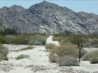
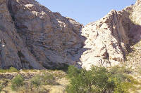 Mile 87.8. 32°18'44.2"N, 114°02'51.9"W. Tinajas Altas and Mesa of the Dead. In the vee of the cove in front of you lie the most significant tinajas in the region. Parking is allowed on the mesa, but camping is regulated. Stopping to "glass" the slopes with binoculars may reveal desert bighorn (Ovis canadensis mexicana) on the granite cliffs. Birds seen here range from golden eagles (Aquila chrysaetos) to lesser goldfinches (Carduelis psaltria), red-tailed hawks (Buteo jamaicensis) to mourning doves (Zenaida macroura), turkey vultures (Cathartes aura) to assorted hummingbirds (Costas hummingbird (male) Calypte costae).
 Often seen near the tinajas are red spotted toads (Anaxyrus punctatus).
Nine intermittent and perennial pools hold at least 22,000 gallons when full. Permanent water made these large tinajas "renowned in the pioneer history of the district," according to Norwegian ethnographer Carl Lumholtz, but he was displeased in January 1910 to find "pieces of cast-off clothing, rusty tin cans, and other cheerless marks of human occupancy."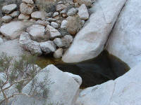 A short walk of about 1,000 feet west into the canyon will take you to the lowest tinaja. If you had been an early traveler you would be wondering: "Is there water today? Will we live or ...?" One 19th century surveyor, David Gaillard, reported that many of the early travelers and gold seekers "made the journey in safety, but others, unused to desert traveling, their insufficient supply of water exhausted, realized their peril, and pushed toward Tinajas Altas. Some perished of thirst by the way; some wandered from the road and never found the water they craved; some reached the tanks, finding the water all gone and too weak to go further, lay down and died; others reached the longed-for spot, but in such a state of exhaustion that, unless water was found in the lower tank, they were too feeble to climb to the next and perished miserably, their horrors aggravated by the thought that water, for want of which they were perishing, was but a few yards off, had they but the strength to reach it.... Three prospectors, who exhausted for want of water, reached the lower tank only to find that some travelers, who had preceded them but a day or two, had emptied this tank. Feeling sure that there was water in the next tank above, they made strenuous efforts to climb to it, but were too weak to succeed, and perished at the foot of the almost vertical slope leading to the second tank, where their bodies were found a few days later, the fingers worn to the bone in their dying efforts to reach the water, which was found in abundance in the tank which they had tried so hard to reach."
An arroyo from a hanging valley in these granitic mountains downcuts steeply through joint fractures to pluck and scour a staircase of pools. Long a prehistoric campsite, Mesa of the Dead was a name applied in honor of the many graves and rock crosses once found there.
Tinajas Altas is the setting of Robinson Jeffers' poem "The Dead Men's Child," which includes lines "his life / Ran smooth because he had nothing future about him. / Men do not stumble on bones mostly but on seeds...."
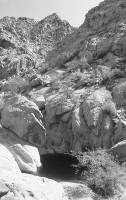
An array of interesting plants thrive among the granite cliffs and slopes. Large woody shrubs called desert sumac (Rhus kearneyi) can be found in shaded north-facing canyons. Visitors will see splendid desert tree-beargrass (Nolina bigelovii) that from a distance looks like yucca, and they may be surprised to see ferns such as Parry's lip fern (Cheilanthes parryi) and desert spike-moss (Selaginella eremophila), and to find on cliff ledges Arizona liveforever (Dudleya arizonica), which botanist Jim Malusa describes as withstanding drought "by withering until it looks like a Fritos corn chip, then springing back to life with the rains." The "caves" that can be seen on the steep slopes are natural geological features called tafoni.
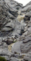 The pools are replenished by runoff during occasional rains, though rarely producing waterfalls such as this one seen by Scott Fischer in September 2013. The pools are carved out by falling, churning water, giving a sense of water's power over millennia even in a desert.
The O'odham name for this place is 'U'uwuak (also, Oo'oowac, or "place where the arrows fell") and the Cocopah name for the mountain range is Xamilkwilau ("lofty water"). These pools have been important to humans for thousands of years. Prehistoric trails led here and more than a dozen Native American tribes, including O'odham, Quechan, and Cocopah, claim Tinajas Altas as part of their culture. As you walk into the canyon, watch for several large boulders featuring deep round holes or small, shallow depressions used by Native people for grinding bean pods and seeds into edible meal.
Mile 87.9. 32°18'47.9"N, 114°02'52.2"W. From the north end of the mesa, the road drops into a sandy wash and then up onto solid ground. From 88.0 to 88.5 the road splits into several routes. Generally go straight, which usually is the best route.
Note the signs encouraging restoration of natural ground. A proliferation of unneeded wildcat roads was confusing drivers and destroying the landscape so the Marine Corps and Bureau of Land Management marked accepted routes. Driving off the road churns living soil into "moon dust," creating places no one wants to camp.
Continue to sign A-16, though you may be tempted by side roads.
Mile 88.7. 32°19'33.4"N, 114°02'59"W Tinajas Altas. Key junction. A-16. Road north (straight ahead) goes to Wellton. Road to the southwest (left) goes to Fortuna Mine and Yuma. Road to the southeast (right) returns to Coyote Wash and distant Ajo, the way you came.
- Prelude and Map
- Introduction
- Leg 1a: Ajo to junction of Darby Well Road and Highway 85
- Leg 1b: Organ Pipe to junction of Darby Well Road and Highway 85.
- Leg 2a: Darby Well Road to Tule Well
- Leg 4: Tule Well to Tacna
- Leg 2b: El Camino del Diablo, Tule Well to Tinajas Altas
- Leg 3a: Tinajas Altas to Goldwater Range northern boundary
- Goldwater Range northern boundary to Yuma and Interstate 8
- Goldwater Range northern boundary to Wellton and Interstate 8
- Leg 3b: Tinajas Altas to Fortuna and Interstate 8
- Alternate route From Leg 3b to Interstate 8
- Epilogue
Copyright Creative Commons
HTML & Programing by
Thomas R. Powell