An Easy Walk Through the Crater Range -
Guided by the CPNHA
 Prepare for the hike. Dress for the
season but be prepared with
protection from the sun year-round.
Sturdy hiking boots are
recommended but not necessary on
this hike unless you intend to
explore some of the more rugged
terrain. On a normal winter day a
liter of water should be sufficient
but bring three or four times as
much in the summer.
Prepare for the hike. Dress for the
season but be prepared with
protection from the sun year-round.
Sturdy hiking boots are
recommended but not necessary on
this hike unless you intend to
explore some of the more rugged
terrain. On a normal winter day a
liter of water should be sufficient
but bring three or four times as
much in the summer.
Access to the area requires a permit
for the Federal Lands which is free
and can be obtained at the Cabeza
Prieta Wildlife Refuge Headquarters
in Ajo, AZ. Its address is 1611 North Second St. Ajo, AZ 85321. The phone number is (520) 387 6483 Allow a half hour to
watch a safety video and complete a form to receive the permit.
Leaving the Cabeza Headquarters turn north on Route 85 towards Gila Bend
and drive for approximately 10 miles until you get to gate 15 on the east (right) side of the road. You will have the
combination with your permit. Let yourself in and close the gate behind you. Please do not abuse the privilege of exploring
the desert on Federal lands and practice leave no trace hiking. 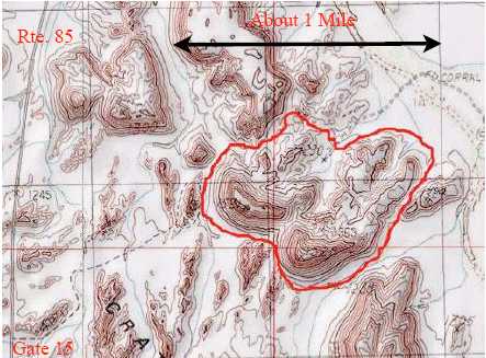 The walk can begin here as the terrain at gate 15 is part of
Crater Range but this particular hike will begin about a mile
from the gate. The road is fairly good for almost any vehicle.
There is a small area to park designated by a stone fire ring
near 32º 33.16 N, 112º 52.10 W.
The walk can begin here as the terrain at gate 15 is part of
Crater Range but this particular hike will begin about a mile
from the gate. The road is fairly good for almost any vehicle.
There is a small area to park designated by a stone fire ring
near 32º 33.16 N, 112º 52.10 W.
The elevation change is almost zero as you can walk on flat
terrain between the rock spires and volcanic upheavals.
Additional difficulty is added at your discretion or expertise,
by exploring higher up. Proceed due east into the first valley
with one note of caution. After you have walked through
several valleys, or calderas, essentially little box canyons
surrounded by volcanic formations, it can become very
disorienting as they are similar in appearance. It is highly
recommend that a global positioning device (GPS) be used to
retrace the route when needed. The map shows a total walk
of over 2.5 miles but much shorter routes are rewarding.
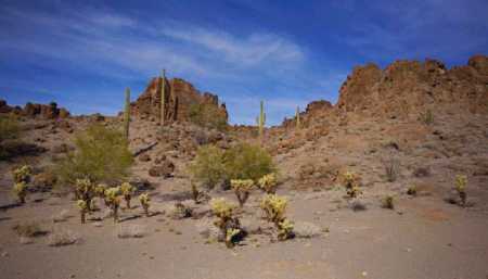
Range Formation. Crater Range is comprised of several miles of volcanic upheavals on both sides of Highway 85 about 10
miles north of Ajo, AZ. Not all of it is accessible for exploration due to its inclusion in the active part of the Barry M.
Goldwater Proving Grounds. The geology you will experience is generally irregular lava flows, layers of tuff and volcanic
breccia. It is not a crater at all but is the erosional remains of volcanic features. The ridges are the remains of dikes which
are more resistant to weathering than the tuff surrounding them. Numerous sharp spires were volcanic conduits for molten
magma and, like the dikes, weather more slowly. The lighter colored hills show evidence of precambrian granite and gneiss.
That said, it is the fascinating arrangement that will hold your attention as you walk from one canyon to the next. The colors
of the geology change often from the expected black volcanic rock to reds and browns and beige.
Based on the time of day you enter the area one could see many types of wildlife ranging from Big Horn Sheep and Mule
Deer to lizards and many of the birds found in the Sonoron Desert.
 A seasonal tinaja in the range holds water for long periods following
rains and brings in many of these animals. The terrain displays the
many forms of plants and cacti found in the Sonoron Desert.
A seasonal tinaja in the range holds water for long periods following
rains and brings in many of these animals. The terrain displays the
many forms of plants and cacti found in the Sonoron Desert.
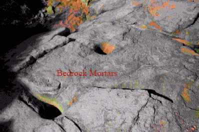
There is a slight indication of a trail that bends to the northeast
through several canyons. A sharp eye will be able to detect evidence
of ancient cultures. One piece of this evidence is the mortars carved
into the horizontal bedrock for grinding seeds of the local trees.
Another is on the vertical rock surfaces in the form of both ancient
and modern petroglyphs. This hike will take about 2 hours but the
beauty of the terrain and the expanse of area could easily use up
several days of repeated exploration.
Return to Desert Destinations Page
Copyright Creative Commons
HTML & Programing by
Thomas R. Powell